Starling Travel

August 7, 2012

Proposed New Trails and Campgrounds at Mount St. Helens
Filed under: Camping,Places To Visit,Washington — Laura Moncur @ 7:54 am

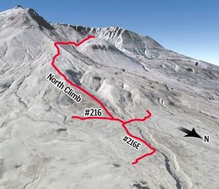
Mount St. Helens Proposed New Trails 2012 from Starling TravelHeraldNet.com reports that the Forest Service is looking at adding trails and campgrounds to the Mount St. Helens National Monument.

The Forest Service is studying the possibility of adding one or two campgrounds and two trails at Mount St. Helens, including a new climbing route on the north side of the volcano. Plans call for starting the environmental review this summer on a trail that departs from Loowit trail No. 216 and climbs to the Sugar Bowl, a rim at about 6,800-feet elevation on the northeast side of Mount St. Helens. Although the trail would not go to the summit, “you’d be able to look right into the crater,” said Gary Walker, lead climbing and trails ranger, for the monument. Climbing on Mount St. Helens has been done only from the south side since the summit reopened in 1982. The number of climbers is limited during summer. A northern route high on the mountain would need to become part of the permit system.

The second trail would begin near the Ape Cave on the south side of the peak and use a former logging road to climb about a mile to a viewpoint of Mount St. Helens. “There’s no view of Mount St. Helens from the Ape Cave,” Romano said. “This would give a fuller experience.”

Locations are being analyzed for two proposed campgrounds near the Science and Learning Center at Coldwater, the new name for the former Coldwater Ridge Visitor Center. The Forest Service wants an overnight facility near the Science and Learning Center as a means for visitors to extend their stays and for research and education groups participating in multi-day programs. Romano said the terrain does not make locating campground sites easy. “There’s not a whole lot of flat ground out there,” she said. “We’ve identified a few places where a small campground might fit.” The sites would be small, with no electricity, toilets without running water and no campfires. Both campgrounds would be within easy walking distance of the center. “We’re still working on the feasibility study,” Romano said. “We’ll know more in a few months.”
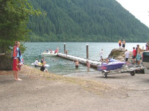
Beaver Bay Campground from Starling TravelRight now, the closest camping to Mount St. Helens is the Beaver Bay Campground, 11 miles (25 minute drive) away. That site is hosted by Pacificorp and is not a state or federal campground, but it has water, showers and a swimming beach. It’s not that far of a drive from Beaver Bay to Mount St. Helens, but I can understand why the Forest Service might want to keep visitors at their site instead of watching them leave the mountain every day.

Via:
January 17, 2012

A View from Cape Disappointment

Filed under: Camping,Places To Visit,Washington — Laura Moncur @ 10:00 am

I love this video recording campsite number 104 at Cape Disappointment in Washington State.

How did Cape Disappointment and Dismal Niche get their name? According to Wikipedia, it was named by a member of the Lewis and Clark team in 1805. They were trapped there by a storm and called the place a dismal niche. The name stuck, but it was not a fair assessment. The place looks like a dream!

Here is a video of the lighthouse at night:

Here is a video of Beards Hollow at Cape Disappointment. It’s better if you mute the audio because the music is rather intrusive.

Next time you’re planning a trip in the Pacific Northwest, take a look at Cape Disappointment. It promises not to live up to its name!

February 1, 2010

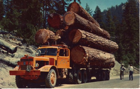
Postcard of the Week: Logging Truck October 1963

Filed under: Places To Visit,Postcards,Washington — Laura Moncur @ 10:00 am

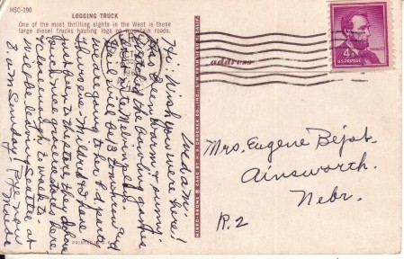
This week’s postcard was sent to Mrs. Eugene Bejot in Ainsworth, Nebraska on October 1963.

Logging Truck Washington

The postcard reads:

Logging Truck

One of the most thrilling sights in the West is these large diesel trucks hauling logs on mountain roads.

Postcard to Mrs. Eugene Bejot

The letter to Mrs. Bejot reads:

Wed a.m.

Hi: Wish you were here! It has been warm and sunny. Watched the bowling games last nite. Melvin plays. Gail will be 13 tomorrow and we are going to her b.d. party Thurs eve. Mildred and I have just been to the store, they do have such nice grocery stores here and close enough to walk to. Will be leaving Seattle at 8 am Sunday.

Bye now, Maude

The postmark is from Everett Washington, which is a small town north of Seattle.


View Larger Map

January 27, 2010

Postcard of the Week: Seattle’s World Fair 1962

Filed under: Places To Visit,Postcards,Washington — Laura Moncur @ 10:00 am

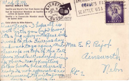
This week’s postcard was sent to Mrs. E. P. Bejot in Ainsworth, Nebraska on July 11, 1962.

Postcard of the Week: Seattle's World's Fair 1962

The postcard reads:

Seattle World’s Fair from Queen Ann

Color photo by Mike Roberts

Postcard of the Week: Seattle's World Fair 1962

The letter to Mrs. Bejot reads:

Dear Grace,

I hope all is well with you but I know it’s a big worry with Gene sick. I went to the fair one day and want to go again. Was clear up on top of the tall Space Needle. Wonderful views up there. Nearly 4 million folks have been there all ready. Is not expensive as was rumored. I’ll write soon.

Love, Calla L.

The Space Needle has become Seattle’s most recognizable landmark, but it was built for the 1962 World’s Fair. You can find out more here:

The Century 21 Exposition (also known as the Seattle World’s Fair) was a World’s Fair held April 21, 1962, to October 21, 1962 in Seattle, Washington, USA.[1][2] Nearly ten million people attended the fair.[3] Unlike some other World’s Fairs of its era, Century 21 ran a profit.[3]

As planned, the exposition left behind a fairground and numerous public buildings and public works; some credit it with revitalizing Seattle’s economic and cultural life (see History of Seattle since 1940).[4] The fair saw the construction of the Space Needle and Alweg monorail, as well as several sports venues and performing arts buildings (most of which have since been replaced or heavily remodeled). The site, slightly expanded since the fair, is now called Seattle Center; the United States Science Pavilion is now the Pacific Science Center. Another notable Seattle Center building, the Experience Music Project, was deliberately designed to fit in with the fairground atmosphere, but was built nearly 40 years later.

You can still visit the Space Needle today and go “clear up on top.”

From the top of the Needle, one can see not only the Downtown Seattle skyline, but also the Olympic and Cascade Mountains, Mount Rainier, Mount Baker, Elliott Bay and surrounding islands. Photographs of the Seattle skyline often show the Space Needle in a prominent position, even appearing to tower above the rest of the city’s skyscrapers, as well as Mount Rainier in the background. This occurs because the tower, which is equivalent in height to a 60-story building, stands roughly four-fifths of a mile (1.3 km) northwest of most downtown skyscrapers.

Where: Space Needle‎
400 Broad St, Seattle, WA‎ Google Map
Phone: (206) 905-2100‎


View Larger Map

-

Powered by WordPress
(c) 2005-2017 Michael Moncur, Laura Moncur, and Starling Studios